
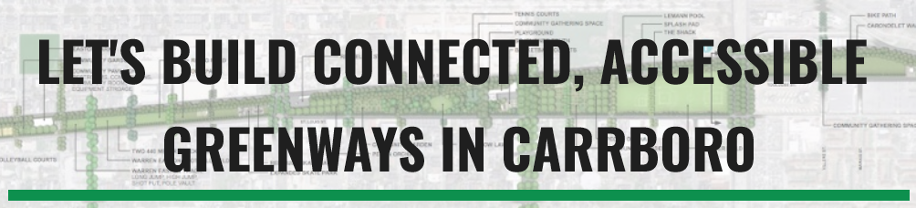
You may have heard the Town of Carrboro has a new survey about the Bolin Creek Greenway that, among other questions, asks which trail alignment respondents prefer: Creekside, Upland Forest, or Bolin Connector.
What are these alignments and how should you respond to this question on the survey?
Back in 2008, the town received funding from USDOT to create a conceptual plan for the long envisioned Bolin Creek Greenway. The town contracted with Chuck Flink and Greenways Incorporated, a well known greenway planning and landscape design firm. Mr. Flink helped design and build the Grand Canyon Greenway, the American Tobacco Trail, and dozens of other greenway projects around the world.
During the public engagement phase of the conceptual master plan, the consultant asked residents, staff, and stakeholders to envision alternative routes as a way to bring into focus the tradeoffs inherent with different types of greenway trails. This approach recognizes that there are challenges with any alignment, but the town endeavors to adopt a design that best meets the project’s goals of increasing accessibility, environmental restoration, managing recreational use, creating safe routes for non-motorized travel, and other such objectives.
The alignments are described in great detail the 2009 conceptual master plan, but here’s a quick rundown of what they are and the tradeoffs they ask us to consider.
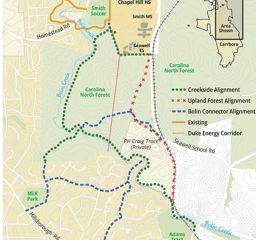
Let’s start with the easiest alignment to discard: Bolin Connector. The Bolin Connector alignment helps us answer the question: “What if our greenway was a bunch of bike lanes on roads shared with cars?”
The Bolin Connector alignment would be cheaper to build (because you aren’t building much; the roads are already there). But the majority of people who use the Bolin Creek Greenway in Chapel Hill are walkers, not bikers. Greenways are great ways to be near nature. Back in the 2009 public engagement process, the community rejected this alternative because, well, it’s not really a greenway if you are walking or your kid is riding a bicycle directly next to a car and having to navigate cars pulling out of driveways.
The next alignment to consider is the Upland Forest alignment. Hot take here, but I stand by it: The Upland Forest alignment is environmentally the worst option because it requires the most trees to be cut down and doesn’t do anything to improve conditions along the creek. Let me explain.
The Upland Forest alignment was created to illustrate the tradeoff between locating a greenway near a creek versus further upland. All things being equal (and that is an important caveat!), an upland route has certain advantages because it would be located outside of the floodplain. Once you get outside the floodplain, it opens up opportunities to use cheaper, pervious materials like gravel. This is a plus for the Upland Forest, but it comes at a pretty high cost in the context of Bolin Forest.
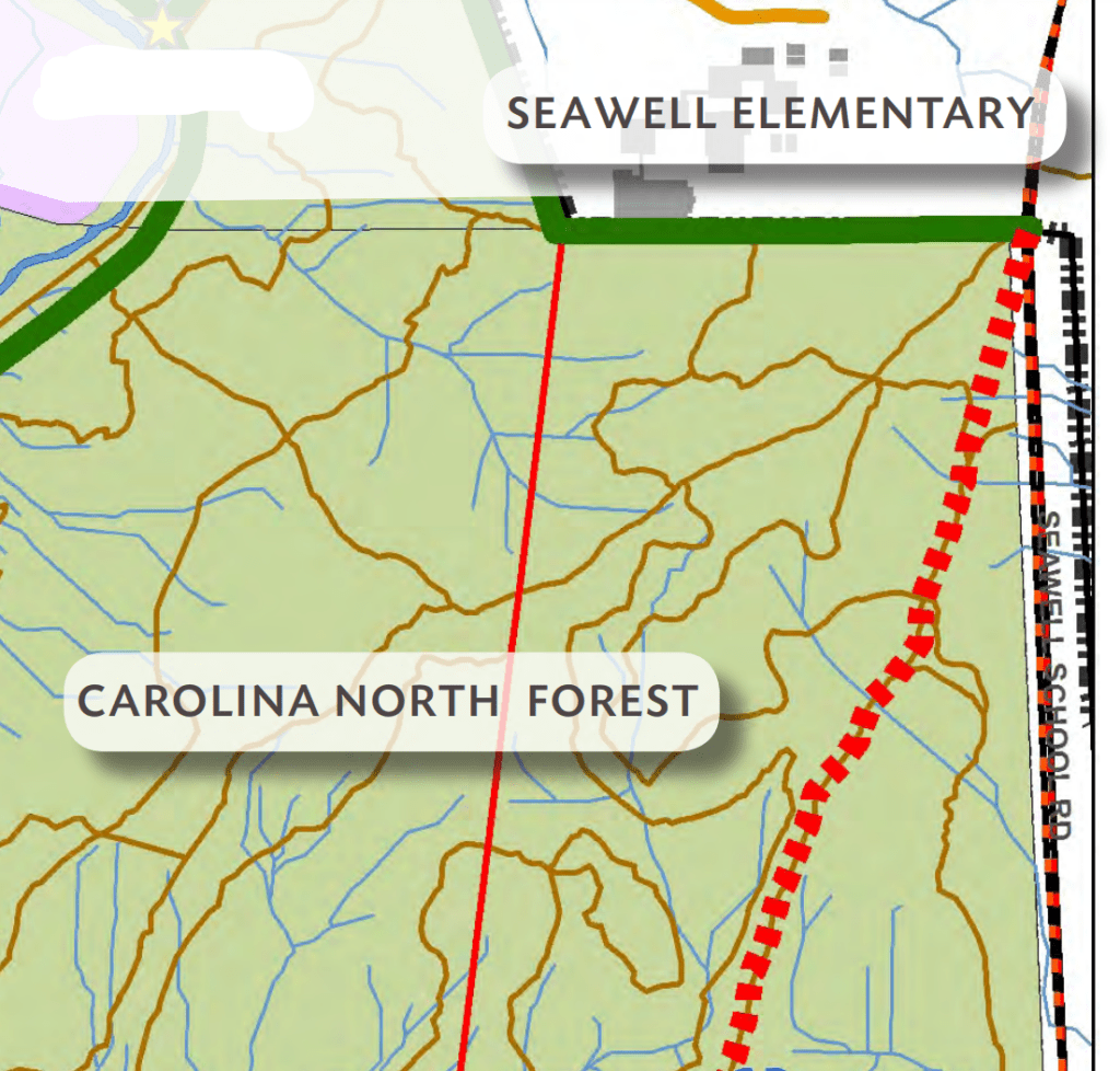
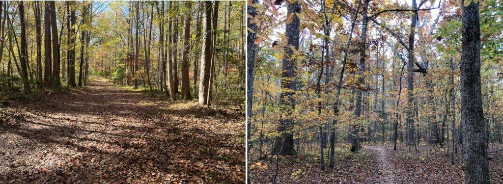
On the UNC Carolina North Forest property (known as Phase 3), the Upland Forest route would follow existing forest service roads and singletrack mountain bike trails, ranging in width from 18 inches to 15 feet. In order to construct an ADA-compliant path using these primitive roads and trails, it would be necessary to clear trees. A lot of trees. A greenway trail would require widening the narrow mountain bike trails by cutting down the surrounding trees. The consultant’s report noted that the mountain bike and trail running community would not be in favor of this alignment because it would interfere with the existing trail system.
Back to the caveat “all things being equal.” In the choices between the Upland Forest and Creekside alignments, things are most certainly not equal. Rather, the choice here is between cutting down trees to build a corridor wide enough for a greenway trail (Upland) versus retrofitting a greenway trail into an existing cleared corridor made by the sewer easement along the creek (Creekside.) In other words, the trees are already removed from the Creekside trail because it’s already a sewage easement that is kept clear of trees.
The Upland Forest alignment would also not do anything to mitigate the damage along the creek caused by the sewer easement, which is something we can do with the Creekside alignment. Using the existing 30-50 foot easement and defining a hardened path for maintenance vehicles, feet, bike and wheelchair tires frees up a lot of critical area near the creek where we could focus on seeded vegetative buffers to slow storm water entering the creek. There is more information about this below in a staff memo prepared by Carrboro based on information received from UNC, OWASA, and state-level experts in water quality.
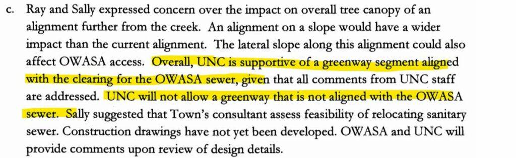
The additional disturbance required to build an upland trail was also cited by UNC officials when they met with town staff back in 2009 to discuss the possible greenway routes. A pretty big blow to the Upland Forest alignment is that UNC has already told the town they would not allow it. UNC will only allow the Creekside alignment on the Carolina North property.
If folks are recommending that you pick the Upland Forest alignment, you should ask them to explain how that would result in fewer trees cut down than using an existing cleared easement. Or how the Upland Forest alignment would improve conditions along the creek. Or how many people who live in Carrboro would be able to access it. (It doesn’t connect any neighborhoods near Greensboro St., Hillsborough St., Main Street, or anywhere near downtown.) Or how it’s even possible to move forward with that alignment when the largest property owner has already ruled it out.
Sign up for the Carrboro Linear Parks Project mailing list to get updates on building out Carrboro’s greenway network. Visit the Carrboro Linear Parks Project website for more information. There’s also a helpful FAQ with answers to many questions.
Update: We support the creekside alignment for the reasons detailed here.
So this leaves the Creekside alignment.
It’s worth noting this: Back in 2009 when the conceptual master plan was being completed, the original draft the consultant presented did not actually include the alternative alignments (Upland, Bolin Connector) because public engagement, stakeholder input, and feasibility made the Creekside alignment the clear winner.
After a small group of residents complained, town council required the other alignments be included in the finalized concept plan so that Phases 3 & 4 could be considered again with additional public input. And after 13 years that time has come and this survey is asking you to weigh in.
We’ve written elsewhere about why the Creekside alignment is really the only option that works, but the best case made for the Creekside alignment was made by town staff back in 2009. Staff working with the consultant on the concept plan drafted a memo to the town council which accompanied the final report for its adoption. I really do recommend reading the memo for yourself, but here’s the highlights:
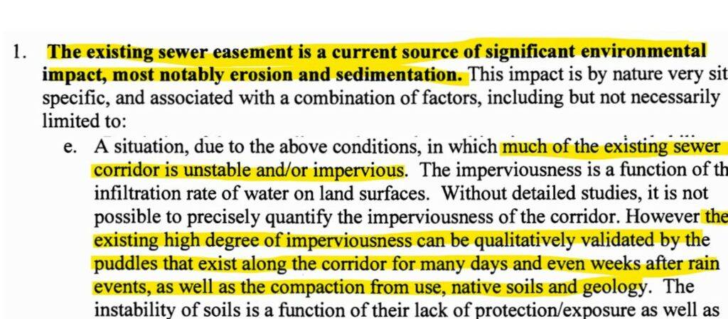
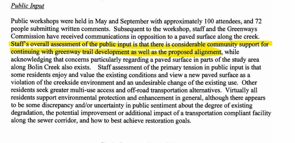
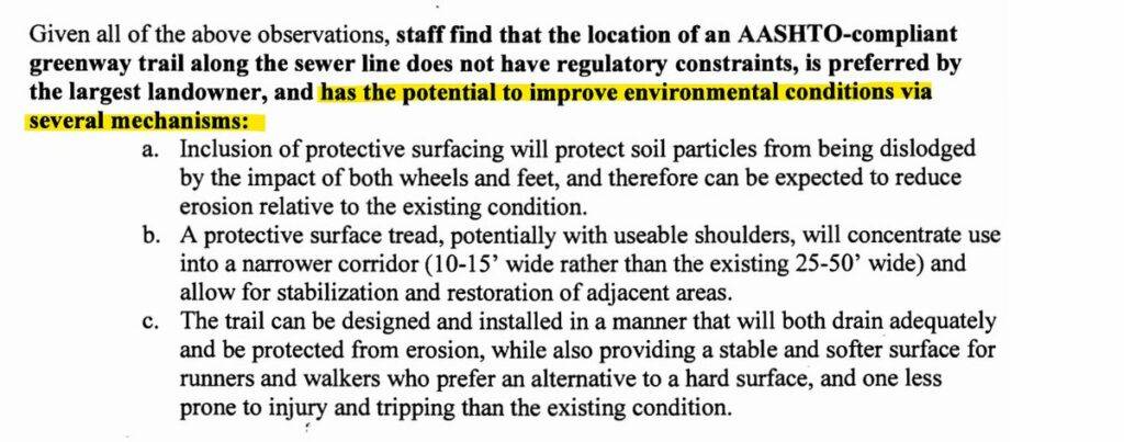
Staff quite emphatically state what anyone who regularly visits the creek already understands: the sewer easement along the creek is a source of environmental degradation and the 30-50 foot clearing is nearly impervious from decades of unmanaged use.
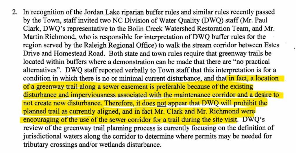
NC water quality officials visited the creek with town staff and indicated that it would be allowed under the “Jordan Lake Rules” and, in fact, they encouraged development of the greenway along the creek.
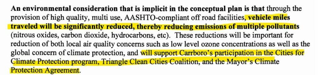
Given how the Creekside alignment would connect neighborhoods to schools and parks, the greenway would “significantly” reduce vehicle miles traveled and aligns with the town’s climate goals.
The Creekside alignment was the preferred alignment of the public back in 2009.
Finally, and most importantly if you’re an environmentally minded person: The Creekside alignment represents an opportunity to improve environmental conditions along the creek by providing a defined, hardened surface for trail use and therefore allowing space for revegetation.
So which alignment should you choose? If you’re anything like me and you love the idea of opening this space up to everyone in Carrboro, or reducing vehicle miles traveled, or improving conditions along the creek, or encouraging active school transportation, then I think the Creekside alignment is probably going to be your best bet. Don’t forget to take the survey!