
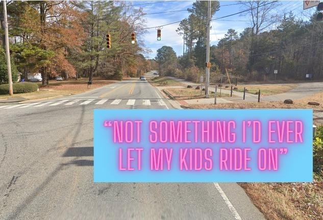
For the past few weeks, an anti-greenway group in Carrboro and Chapel Hill has been sharing a map purportedly showing ‘alternative bike routes’ that could take the place of paving the Bolin Creek Greenway in Carrboro.
The map looks like they threw imaginary bike lane spaghetti at a map of Chapel Hill and Carrboro. Many of the paths are unsafe for kids and anyone with mobility issues. Others will likely never exist in our lifetimes. Some exist, but don’t connect to anything else — and don’t go near Carrboro. Their “alternatives” won’t help us connect neighborhoods, and neighbors, while extending the Bolin Creek greenways would bring us together.
If you’d like to learn more about a group of parents and kids working to make biking and walking to school safer, please join the mailing list for the Carrboro Linear Parks Project.
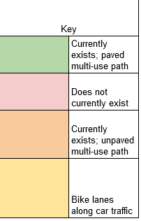
You can see a summary of our analysis here:

And here is the key:
First, we should note the obvious: road bikers — the people you see riding on roads wearing the spandex stuff — are not the primary users of the paved Bolin Creek Greenway in Chapel Hill and we don’t expect them to be the primary users for the paved Bolin Creek Greenway in Carrboro. They also bike along these roads already. We probably won’t see many mountain bikers—who already ride dirt and gravel trails in the Carolina North Forest—on the greenway either.
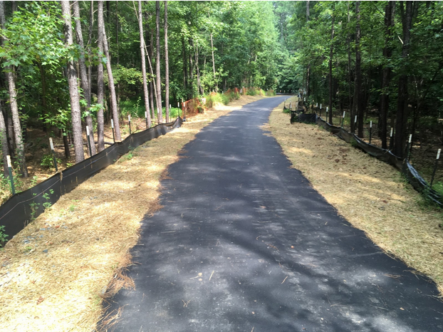
But paved trails like the Bolin Creek Trail in Chapel Hill are for everyone — they provide protected, safe biking and walking routes for kids, older adults, and anyone who wants to be near nature. The one planned in Carrboro is along an existing sewer easement which is 30-feet-wide and doesn’t have trees on it because they could block the sewer pipes. Once complete, the approximately 2-mile-long path will make it possible to travel almost entirely off-road from the planned Twin Creeks Park to Dr. Martin Luther King Jr. Park, to Wilson Park, to Hargraves Park and Umstead Park in Chapel Hill, and ultimately to University Lake and Southern Village Park. It’s the missing link (in green) in a connected trail network in our towns.

Data from the Town of Chapel Hill shows that pedestrians — people who walk — are the primary users of the paved Bolin Creek Greenway in Chapel Hill.
That’s likely because the 10-foot-wide paved path makes it easy to avoid roots, stay on level ground, and avoid mud and puddles that can be bad for both animals and erosion.
Many of the routes on the ‘alternative bike map’ are imaginary – they don’t exist and will likely never exist in our lifetimes.
We took a look at the ‘bike map’ that is being shared as an alternative to the paved greenway. Essentially, a third of the routes are for the spandex road cyclists, a third are for full suspension mountain bikes, and a third are fantasy routes.
Most importantly, they’re largely a non-starter for kids who would use the paved greenway in Carrboro to get to Chapel Hill High School and Smith Middle School. Some of the routes rely on UNC greenlighting projects that the anti-greenway advocates have fought in the past. Some have steep hills and scary curves that even the road bikers among us avoid. Others don’t exist, and likely will never exist. All of the intricacies of who owns which roads and the ways in which projects are prioritized and funded is not present.
You can’t just draw a map and make it so.
We convened a range of bikers, from road bikers to a “boardwalk biker” to a 5-year-old, to give their opinions on safety, feasibility, and ease of use.
Our panelists:
John leads Bike Chapel Hill, rides road bikes, and is comfortable riding with traffic.
Mel has a “mom bike” with three gear and will never ride with traffic – but recently participated in Bike to School Day for Carrboro Elementary School. She does not have a way to transport her bike to the paved path in Chapel Hill right now — the bike doesn’t fit in her car.
Martin has a cargo e-bike that he uses to take his kids to school, pick up groceries, and go to work. Before he got a cargo bike, he used a hybrid bike to get around downtown, but he rarely went further afield because of the hills.
Asher is 5 and just learned to ride a two-wheeler without training wheels.
Geoff rides an e-bike and just let his 14-year-old ride to East Chapel Hill High School via bike.
1 Homestead-Chapel Hill High School Multi-Use Path (aka Bolin Creek Phase 1B)
What is this?
This greenway connects the Claremont and Winmore neighborhoods with Chapel Hill High School, Smith Middle School, and Seawell Elementary School. Planning work on the trail began in 2009. In 2016, the Carrboro Town Council (then called the Board of Aldermen) voted to fund the bike path, though former council member Jacqueline Gist and current council member Randee Haven-O’Donnell voted against it at various points along the way. At the time, neighbors were concerned that the paved trail would increase flooding, but that hasn’t happened since the trail opened in 2018.
Did the anti-greenway group who made the “alternative bike map” try to stop the Homestead-Chapel Hill High School Multi-Use Path?
Yes, they tried to derail the trail’s completion.
Our take on this route
This is a fantastic trail for people who live in these three neighborhoods on the edge of town, but it isn’t connected to anything else. It’s useful for kids in those neighborhoods to get to school. It would be amazing if they connected to the Bolin Creek Trail so people could walk, roll, or bike all the way into town.
Would you feel safe riding this?
Martin: Yes, though I’ve only been once, and had trouble finding it. Maybe the town could put it on a map?
Mel: Yes, if I could get there. My neighborhood doesn’t connect to this trail and I don’t have the hitch thing for my car – we’re a one-car household – and so I have never gone on a bike on this trail. It looks like a nice spot to walk along with my in-laws who need to walk on paved, smooth surfaces.
John: Yes. I have ridden it many times
Geoff: Yes. it’s a great path though somewhat hard to locate.
Asher: [answer dependent on Mel’s willingness to shepard him there] Yes.
Would you let your kids ride this?
Martin: Yes.
Mel: Yes, if we could get there.
John: Yes
Geoff: Yes
2 Homestead Road Bike & Pedestrian Enhancements
What’s difficult about this route?
This doesn’t exist yet. In Chapel Hill between Seawell School Rd and Weaver Dairy Ext, NCDOT just authorized the town to proceed with a bid for construction. There will be bike lanes and in some part probably an multi-use path. As far as improvements to Carrboro go, we’re not sure — but this is the type of bike lane that you ride “alongside traffic” not “separated and safe.”
Would you feel safe riding this?
Mel: No.
Would you let your kids ride this?
Mel: Homestead drivers go very fast. Currently, absolutely not.
3 MLK Jr. Boulevard Bikepaths
What’s difficult about this route?
It’s hilly, on a road with rampant speeding. The majority of the town’s deaths occurring between people driving cars and people walking or biking have been on this road. It is currently not safe to ride for people of any ability.
Would you feel safe riding this?
Martin: No.
Mel: Hahahaha no.
John: No. I ride a road bike on rural roads to Mebane and Saxaphaw and even I won’t ride on this. When I need to get to destinations served by this route I usually mix it up with the NS bus or take really out of the way routes.
Geoff: I have ridden it each time it’s been a miserably uncomfortable experience.
Would you let your kids ride this?
Martin and Mel: Absolutely not.
But, wait! A multi-use path will be built on MLK as part of the NSBRT project if that project gets funded.
4 Carolina North Bicycle Connector
What’s difficult about this route?
This is technically in the Carolina North Forest Master Plan, but it would be decades and decades off. There’s no reason to even speculate what this would be like; it’s essentially vaporware. The funny thing is that the anti-greenway folks will likely fight whatever the university tries to do on this site — as they have done in the past.
Would you feel safe riding this?
Mel: If I’m alive when it’s built, maybe?
Would you let your kids ride this?
Mel: They walk along the Pumpkin Loop so I guess if UNC builds this in four decades, sure — but my kids will be in their 40s then.
Martin: Sure. This is a good reminder of all the great trails we have in Carolina North that are difficult for outsiders to find. While there’s an okay map online, you would only come across it if you’re really into hiking trails or live nearby.
5 Seawell School Road Bike lanes or Multi-Use Path
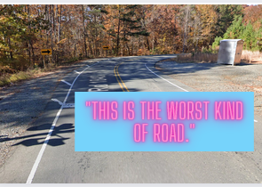
What’s difficult about this route?
Seawell School Road is a narrow, two-lane road with no sidewalks for most of the long stretch between Seawell School Road and Estes Drive Extension. It lacks a paved shoulder, much less sidewalks or any multi-use path. There’s no plan to add these facilities in the near future, and one big challenge is that the route crosses the still-active railroad that brings coal to the UNC cogeneration plant. Along with the safety issues that poses, there are massive coordination challenges in building bicycle and pedestrian facilities across active railroad tracks.
Would you feel safe riding this?
Martin: No. The blind curve is scary enough in a car. This is the worst kind of road, one that feels like a rural stretch of highway but is in fact rather busy, particularly during school hours. Even if they built a sidewalk I would worry about distracted drivers, including high school students, hitting someone.
Mel: lololololono
John: Yes. I am pretty ok with riding this. However, I am a road cyclist with many decades of experience. I never took my kids on this route.
Geoff: Not particularly.
Would you let your kids ride this?
John: No way
Geoff: In the fantasy world where there is found the money, the political will, and the engineering expertise to build a path well separated from the roadway, then yes! In the real world, no no no.
Martin: No
6 Estes Drive Bike lanes and Multi-Use Path
Chapel Hill and Carrboro are planning to put bike lanes and/or a multi-use path on this section of Estes, continuing what’s currently under construction between MLK, Jr. Boulevard and Franklin Street. For now, though, this is an incredibly unsafe road, with disappearing bike lanes, blind curves, and a lot of distracted drivers. (Not to mention the hill as you approach Carrboro).
What’s difficult about this route?
Fast moving traffic with nothing but a shoulder that disappears in places.
Would you feel safe riding this?
Martin: No. I avoid it if at all possible.
Would you let your kids ride this?
Mel: If the cars go as fast as they currently do on Estes, then no.
7 Wilson Park Bikeway/Greenway
What’s difficult about this route?
Not much. It has a slight grade heading into the park.
It’s a useful connection for Estes Park Apartments to get to N. Greensboro St. without riding up the hill in traffic on Estes. But, without being connected to a greenway network, it is limited in usefulness. It is worth pointing out that this is Bolin Creek Greenway “Phase 1A” and was supposed to continue up Estes to the railroad tracks where it would connect to Phase 4 along the creek.
Would you feel safe riding this?
Martin: Yes, for about three minutes I can pretend to live in a place that prioritizes greenways.
Mel: sure, but I wouldn’t feel comfortable riding once I got to the end of it.
John: Yes. I ride it all the time. It allows me to avoid Estes drive as it climbs towards Greensboro street and narrows significantly. I find it odd this route is included as FOBC used this as an example of what should be stopped. They don’t like this path, which enables a safe route to Wilson park by the residents of the Estes Park apartments!
Would you let your kids ride this?
John: Yes
Mel: Sure, for the 2 minutes this greenway exists (but I’m not sure how he’d get there!)
Martin: Yes
8 Campus-to-Campus Bicycle Connector
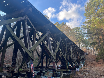
What’s difficult about this route?
The biggest problem is it doesn’t exist. And there is no immediate outlook for it to exist, or maybe ever exist. The C2C connector was proposed as part of the development agreement for Carolina North between UNC and the Town of Chapel Hill. Aside from some preliminary public engagement activities more than a decade ago, no work has been done on this project. There is no preliminary route, no plan for further study, and no identified safe way to get from campus to the Carolina North area.
Would you feel safe riding this?
Martin: No. I recently saw someone walking on the scary wooden railroad bridge (bisected by the Bolin Creek trail) and was shocked that people would take such risks. I’m not an engineer, but I have a hard time imagining people walking across a bridge that looks like something you’d see at an abandoned amusement park. They’d probably have to replace it, which would cost a ton of money.
Mel: No.
John: LOL No. It is unsafe and illegal to ride on railroad right of ways
Would you let your kids ride this?
Martin: No
Mel: If you ever see my children on this, call me.
9 Bolin Creek/Tanyard Branch Paved Trails
In Chapel Hill, the Bolin Creek trail was built in several sections. In 2018, the greenway was extended across MLK, Jr. Boulevard, going to Umstead Park. Around the same time, the Tanyard Branch Trail, which connects to the Northside neighborhood, opened.
What’s difficult about this route?
Nothing. This is the paved Bolin Creek Trail in Chapel Hill which is quite lovely and used by thousands of people each month. This is what we’d like to extend into Carrboro.
Would you feel safe riding this?
Martin: Yes, It’s hard to believe that people are opposed to extending this trail. I currently use it to get to the library and the Eastgate shopping center. I even biked with my kids to Cook Out.
Mel: We walk on this all the time. The library has a story trail along it — it’s great and a nice way for the library to extend services.
John: Yes- I ride it frequently
Geoff: Absolutely — this is one of my routes to safely get to downtown Chapel Hill and Carrboro.
Would you let your kids ride this?
John: Yes! We have ridden and also skated Bolin Creek for nearly 20 years
Martin: Yes, I love the Bolin Creek trail. It’s one of the few places where I feel like I see all of Chapel Hill.
Geoff: I would and they do.
10 Carolina North Tripp Farm Road Connector
This segment was listed as an “alternative” in the Bolin Creek Greenway Concept Plan called the “Bolin Connector”. It was not incorporated into the proposed design because most of the route relied on existing roads and parents didn’t want their kids riding on roads, they wanted a greenway. This segment is a dirt path that crosses a rocky easement, then climbs a number of hills to reach Seawell School Road. It’s not even close to “all ages and abilities” nor is it ADA compliant. Here’s what it looks like after a rain:
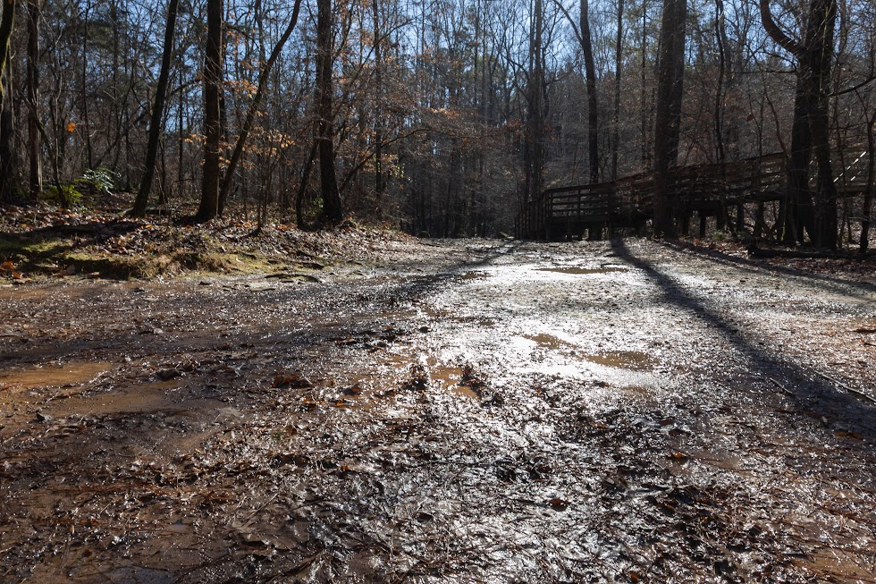
What’s difficult about this route?
See above. (Alt text: A muddy rutted path.)
Would you feel safe riding this?
Martin: Yes, if I had a mountain bike.
Mel: Do I need a mountain bike to answer this? I don’t have one of those.
John: Yes, on a mountain bike.
Would you let your kids ride this?
Mel: I don’t think my kids would be able to bike or walk through this.
11 Seawell School Road to Bolin Creek Northern Route
What’s difficult about this route?
This is a forest access road that is mostly gravel. It is useful if you’re on Seawell School Rd and want to ride to Bolin Creek without getting on the singletrack mountain biking trails, but it is not a route to any other destination. Coming up from the creek on this road is very steep; no kid or unfit adult is riding up this. Putting this on a “bike route alternative” map is grabbing at straws.
Would you feel safe riding this?
Martin: Yes, on a mountain bike, if I had one.
Mel: Do I need a mountain bike to answer this? I don’t have one of those.
John: Yes, on a mountain bike.
Would you let your kids ride this?
Mel: I don’t think my kids would be able to bike or walk through this.
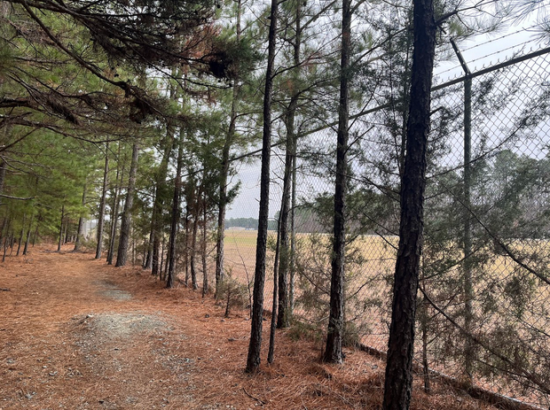
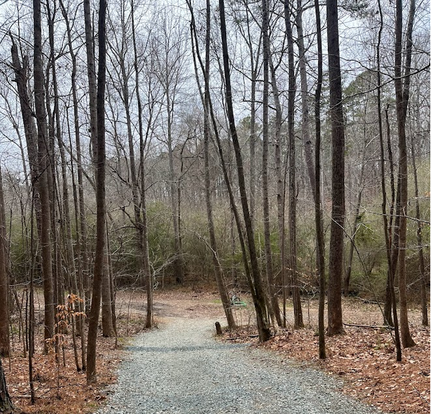
12 Pumpkin Loop, Off-Road Carolina North Unpaved Trails
The Pumpkin Loop is one of the most popular trails in Carolina North Forest. If you go on any nice weekend day you’ll find dozens of walkers, many with dogs. While mountain bikes and so called “gravel” bikes have no problem dealing with the rocks and a few hills that are on the trail, bikers don’t really seek it out.
And, in case the meaning of the name escapes you, Pumpkin Loop is a loop. In the middle of woods. Almost everyone on the trail gets there by car, taking a bumpy dirt road to get to a small parking lot. While you could conceivably get there by bus (the NS stop is a half mile away), walking on a busy dirt road isn’t all that fun.
Would you feel safe riding this?
Martin: I used to go here occasionally. But then I went one day, couldn’t find parking after driving on the bumpy road, turned around and decided to only hike on trails that were easier to access.
Mel: We walk this route often after we drive to it.
John: Yes.
Would you let your kids ride this?
Martin: Yes, but it’s hard to imagine a scenario where they would.
13 Cobblestone Bike Boulevard Northbound
What’s difficult about this route?
It’s sort of useful but only because none of the roads between these neighborhoods connect like they should. It involves riding on sidewalks between adjoining cul-de-sacs. Cobblestone Rd is a long, somewhat punchy climb to Pathway, so much so that it is listed as a competitive road segment on the Strava fitness app. This is the kind of hill that turns bike trips with kids into car trips with kids.
Would you feel safe riding this?
Martin: Yes
Mel: I don’t think I’d be able to do this without a better bike.
John: Yes
Would you let your kids ride this?
We don’t see many kids using this route because it’s so steep. If they had e-bikes, maybe?
14 Multiple Bike Boulevard Routes
What’s difficult about this route?
A painted bike lane on an NCDOT arterial with a 35 mph speed limit is not a “bike boulevard”. Hillsborough Rd has a painted bike lane next to traffic that can regularly be observed traveling about 50mph. The stress of riding on these roads with your children is, again, what turns bike trips with your kids into car trips with your kids.
Would you feel safe riding this?
Martin: Not really. I ride busy streets, like N. Greensboro, when I have to, but I don’t like it.
Mel: No
John: No
Would you let your kids ride this?
Martin: No, I would have them ride on the sidewalk, which is also dangerous, but not quite as dangerous as riding on the road.
15. Powerline Trail
This is a hilly gravel road that connects Bolin Creek trail to Seawell, Smith, and Chapel Hill HIgh School. The easement is controlled by Duke Energy.
What’s difficult about this route?
It’s a gravel trail, really only suitable for mountain bikes and gravel bikes. The steep hill is difficult to climb for all but the most athletic cyclists, and we could easily imagine someone losing control of their bike and crashing into the creek going downhill. If we paved this trail, we’d probably want to introduce switchbacks, which would raise costs significantly. In addition, Duke Energy reserves the right “to close, without notice, all or a portion of the trail located within the transmission line easement, for any length of time, for construction, maintenance or emergency line operations.” We don’t know how likely this is to happen, but we’d hate to spend money on a trail only to have Duke Energy close it for weeks at a time without notice. (OWASA is locally controlled – and they publish when they need to do work in advance.)
Would you feel safe riding this?
Martin: I don’t have a mountain bike, so I would probably end up walking my bike on part of the trail.
Mel: No.
John: I’ve ridden it in the past on a full suspension mountain bike. It was fun, but probably not safe for my current age and ability level.
Would you let your kids ride this?
John: Probably not.
Martin: I recently bought my son a mountain bike so he could ride this trail with a friend of his to get to school. It’s a tough ride, but at least it’s safe. But I don’t think this is a solution for everyone, and it might not even work for him.
If you’d like to learn more about a group of parents and kids working to make biking and walking to schools in Carrboro and Chapel Hill safer, please join the mailing list for the Carrboro Linear Parks Project.
This piece was written by John, Mel, Martin, Ryan, Geoff and Asher, who is 5.