Great news, friends! Carrboro has launched the public engagement campaign for the next phases of the Bolin Creek Greenway. (In other words, they want input on where stages 3 and 4 of the greenway will be built. You can see what’s been built already here.)
This is so exciting! We are thrilled that they are moving forward to protect Bolin Creek and provide a safe, accessible path for people to get around town.

Sign up for the Carrboro Linear Parks Project mailing list to get updates on building out Carrboro’s greenway network. Visit the Carrboro Linear Parks Project website for more information. There’s also a helpful FAQ with answers to many questions.
Update: We support the creekside alignment for the reasons detailed here.
They’re asking Carrboro residents to do two things:
- Take the town survey
- Add points of interest and concern to a wikimap – This is where you can say where you’d go on the greenway and what access points you’d like.
The three alignments help people consider trade-offs and consider different approaches for the greenway. We strongly believe that the creekside alignment is the best choice for Carrboro, because it will:
- Be built in an existing 30-foot-wide sewage easement that has already been cleared of trees (Source: Bolin Creek Greenway Conceptual Master Plan)
- State water quality officials told town staff during a site visit in 2009 that it would be allowed under the Jordan Lake Rules (Source: Carrboro Town staff memo)
- Follows gentle grade changes (Source: Carrboro Town staff memo)
- Maximizes opportunities for connections across Carrboro (Source: Carrboro Town staff memo)
- Is the preferred route of UNC, the largest landowner (Source: Carrboro Town staff memo)
- Has the potential to improve environmental conditions via reducing erosion alongside the existing path, as observed in a memo from the Town of Carrboro
- Allow people to walk or bike along a beautiful creekside path without any cars to worry about (Source: Survey given to town residents about alignments)
- Connect our schools to Carrboro, so middle schoolers and high schoolers will be able to safely bike or walk to schools without cars or traffic
- Will deliver access that meets ADA standards to nature and park space for all (Source: Bolin Creek Greenway Conceptual Master Plan)
- Not be in conflict with other existing trails that would affect mountain bikers and trail runners (Source: Bolin Creek Greenway Conceptual Master Plan)
- Connects the largest number of neighborhoods across Carrboro (Source: Bolin Creek Greenway Conceptual Master Plan)
- Connect to existing parking lots (Wilson Park, Chapel Hill High School (weekends)) (Source: Bolin Creek Greenway Conceptual Master Plan)
The creekside alignment was vetted by trail experts who have designed hundreds of trails nationally. It is the best choice for repairing the stream, connecting Carrboro, and making Bolin Creek accessible to all.
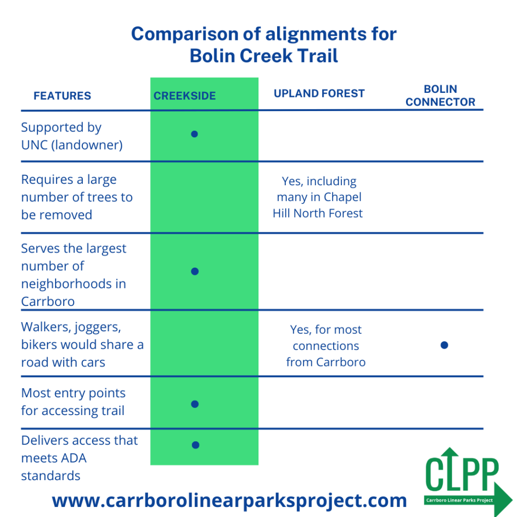
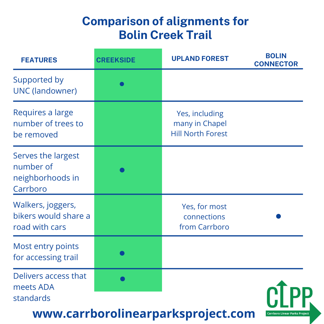
The Upland Forest alternative would require cutting more trees down and would place the path in conflict with other trail users, like mountain bikers and trail runners. It also would not connect most of Carrboro for anyone who lives near Greensboro St. or Hillsborough Street, and would require increased engineering costs and potential ADA accessibility constraints. It also requires permission from a freight railway company that has not approved similar projects to build in their land in the past. The Bolin Connector alternate is mostly an on-street bike boulevard that connected to existing forest service roads. Both would require walkers or bikers to be alongside traffic. There are also additional engineering constraints.
We have summarized the differences in this chart:

You can take the town survey here. The Carrboro Linear Parks Project has an extensive FAQ with questions about the process, environmental concerns, connections, and accessibility. You can also read more on the Town of Carrboro website.

