
In 2008, the Town of Carrboro commissioned Greenways Incorporated, a nationally recognized greenway design and planning firm founded by Chuck Flink, to assess the feasibility of Bolin Creek and Jones Creek for a greenway that would connect Morris Grove Elementary in the north to Wilson Park in the south.
At the time, there was much excitement around the greenway — and a long public engagement process took place. The plan, known as the ✨Bolin Creek Greenway Conceptual Master Plan✨, was completed and adopted by the town council in 2009.
Basically, to cut out the wonky civic planner speak, the ✨Bolin Creek Greenway Conceptual Master Plan✨ is an overall visioning document, and the greenway was envisioned as being completed in stages — called phases — because that’s easier for funding stuff. The ✨Bolin Creek Greenway Conceptual Master Plan✨ is an overview document of how all of those stages will one day :fingers-crossed: connect.
Sign up for the Carrboro Linear Parks Project mailing list to get updates on building out Carrboro’s greenway network. Visit the Carrboro Linear Parks Project website for more information. There’s also a helpful FAQ with answers to many questions.
Update: We support the creekside alignment for the reasons detailed here.
The ✨Bolin Creek Greenway Conceptual Master Plan✨ can be found on the town’s website as 11 separate PDF documents. (Fun fact: Back in 2009, PDFs were uploaded as separate files because most people were on dial-up!)
To save you the trouble of finding all of those documents, we scrounged around the Carrboro Town website, and have linked everything here for your reading pleasure.
Pull up a chair, get comfy, it’s time to read…. 11 PDFs.
Or one PDF – here’s the executive summary
Read the executive summary of the Bolin Creek Greenway Conceptual Plan.
I’m a masochist – give me all 11 PDFs
Chapter 2: Existing Conditions
Chapter 3: Opportunities and Constraints
Appendix A: Public Input Summary
Appendix B: Funding Strategies
Appendix C: Operations and Management
And here’s the Cliff’s Notes version, in case you only made it to PDF number six:
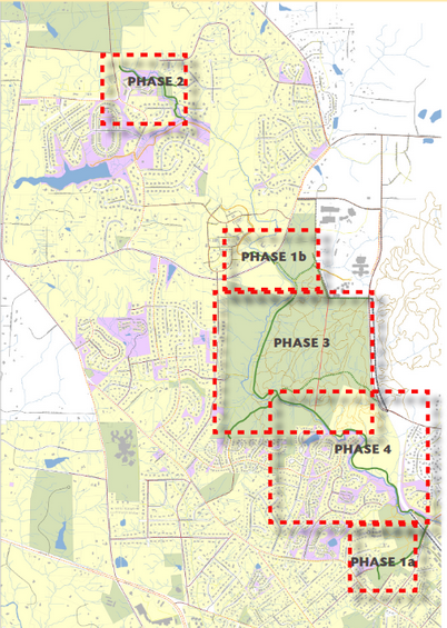
Each phase of the project was given a numerical name as follows:
Phase 1A would connect Wilson Park to the railroad (on Estes)
Phase 1B (Homestead-Chapel Hill High School Multi-Use Path) would connect Carolina North Forest to Claremont
Phase 2 would connect Jones Creek
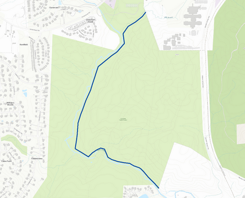
Phase 3 would tackle Carolina North Forest along Bolin Creek
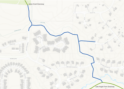
Phase 4 would continue along Bolin Creek through the PH Craig Tract up to the Estes Dr.
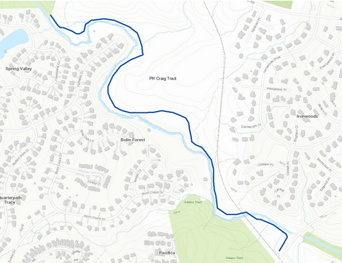
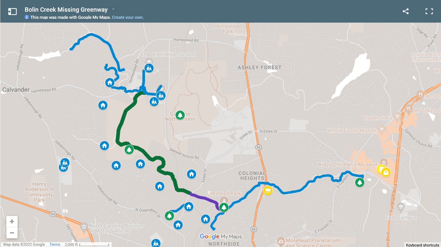
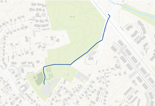
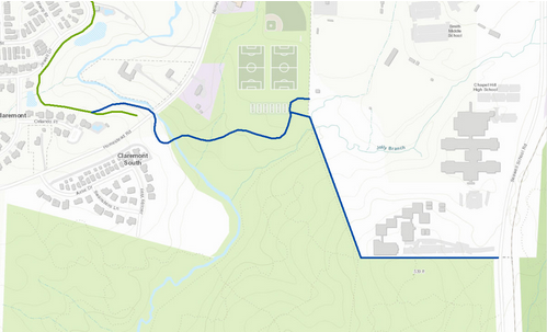
Aside: We think this naming system is hard to follow and overly complicated. It’s easier when you look at the map below and see how they all will :fingers-crossed: one day connect. (They’re named after stages of completion instead of where they actually are.) Here’s the full system plan on a map (top) compared to what the town has been able to build in the last thirteen years (bottom):
And here is a map released by the town showing the phases and locations:
What does the ✨Bolin Creek Greenway Conceptual Master Plan✨ have in it?
The ✨Bolin Creek Greenway Conceptual Master Plan✨ established some common goals for the future greenway, outlined existing connections, identified opportunities and constraints for future trail development, and recommended a phased approach for implementation. The conceptual master plan also solicited public input, through two public workshops, paper forms, and comment forms.
We were supposed to have a 4.8 mile trail!
The proposed design made recommendations for 4.8 miles of trail, from Wilson Park to Homestead Park, and from Lake Hogan Farms to Buckhorn Branch.
Did the ✨Bolin Creek Greenway Conceptual Master Plan✨ examine alternatives?
Yes! One important and often overlooked aspect of the ✨Bolin Creek Greenway Conceptual Master Plan✨ is that it also assessed two alternate alignments for the greenway that did not follow the Bolin Creek sewer easement. These helped people examine trade-offs and think about different approaches.
The “Upland Forest” and “Bolin Connector” alternates were presented to the public and studied by the greenway designers and ultimately rejected in favor of the preferred alignment along Jones and Bolin Creeks. The Upland Forest alternative would require cutting more trees down and would place the path in conflict with other trail users, like mountain bikers and trail runners.
The Bolin Connector alternate was mostly an on-street bike boulevard that connected to existing forest service roads. This alternative was rejected by folks who showed up at the public meetings, many of whom were parents that preferred for their kids to walk and ride bikes on a beautiful creekside greenway as opposed to sharing a road with cars.
The preferred alignment along the sewer easement was considered the most successful in terms of serving the largest number of neighborhoods.
What doesn’t the conceptual plan have in it?
It didn’t have final engineering plans for each section because those are typically done before each stage starts. (These things take a long time!) The conceptual plan acknowledges that ecological, erosion, etc issues for each stage need to be understood better through the process of design and engineering. Actually making the greenways – the topography, the design, dealing with individual constraints – has been done in each stage as it’s been implemented. (We go into more detail about this here.)
So where are we now?
Phases 1a, which connected Wilson Park with Estes Drive, was completed in 2013. It’s a useful connection for Estes Park Apartments to get to N. Greensboro St. without riding up the hill in traffic on Estes. But, without being connected to a greenway network, it is limited in usefulness.
Phase 1b, which is commonly called the Homestead-Chapel Hill High School Multi-Use Path, officially opened in 2018. This allows people in Lake Hogan Farms and Winmore to bike and walk to middle school and high school along a paved, safe path.
And that’s, uh, it.
That’s largely because a small group of people have blocked the largest parts of the greenway — the ones that would connect Lake Hogan Farms and every neighborhood south, from Quarterpath Trace to Cate Farms, to downtown Carrboro via safe, protected walking and bike paths.
What’s happening in 2023? I want my greenway.
You’re in luck, because the Town Council is going to start discussing the greenway this year.
This is great news, for those of us who want our kids to be able to bike safely to middle school and high school. And it’s great news for people who want to exercise along the creek, or to one day get to the Chapel Hill Public Library (which can happen when Chapel Hill extends their part of the greenway to Estes Drive.)
That’s great news! I thought it had stopped for good.
Nope! You might have heard that from the anti-greenway group, but the ✨Bolin Creek Greenway Conceptual Master Plan✨ has never been “shelved” or “tabled.”
Various elements of it that were approved in 2009 have already been implemented. Follow-up on other elements of it has been slow and halting, primarily because of the small group of people who have tried to block the greenway. When there have been occasional attempts to move the conversation forward, including as recently as a Carrboro Town Council work session in June 2018, the group steps in to delay and obstruct. And then when the topic next comes up again, they cynically claim people are trying to “resurrect” something that had been “shelved.”
Are you excited that this project is finally moving forward?
Do I get a text message each day telling me my kiddo’s bus is going to be delayed and I need to scramble and figure out how to balance work and getting my kids to school? Heck yes – every single day.
So yes, heck yeah I’m excited — this will make the lives of parents a heckuva lot easier if our kids have a safe and protected way to bike or walk to school. I love Bolin Creek. I wanted to take my strollers along the creek when my kiddos were born — but it was too muddy and rutted to navigate. Let’s make Carrboro easier to access and more connected!
I’m excited as well. What’s next?
- Sign up for updates on the Carrboro Linear Park Project list. That’s a group of parents and kids who are working hard to push this forward and make Carrboro more connected.
- Write to Town Council in Carrboro and let them know you support safe, connected greenways that help our families exercise, enjoy nature, and go to school safely
Guide: Emailing Carrboro Town Council
Chapel Hill, Carrboro and Orange County have pretty transparent ways of getting in touch with our elected officials, which you can do if you have an issue, want to bring something to their attention, or just thank them. Here’s how to do it.
- Town Council will be discussing the public engagement process for this on February 14. We’ll have a recap for you — you can sign up for the Triangle Blog Blog newsletter here.
This post was written by Ryan Byers and Melody Kramer. They both live in Carrboro and look forward to the day when they can bike safely around town and to school with their families.