
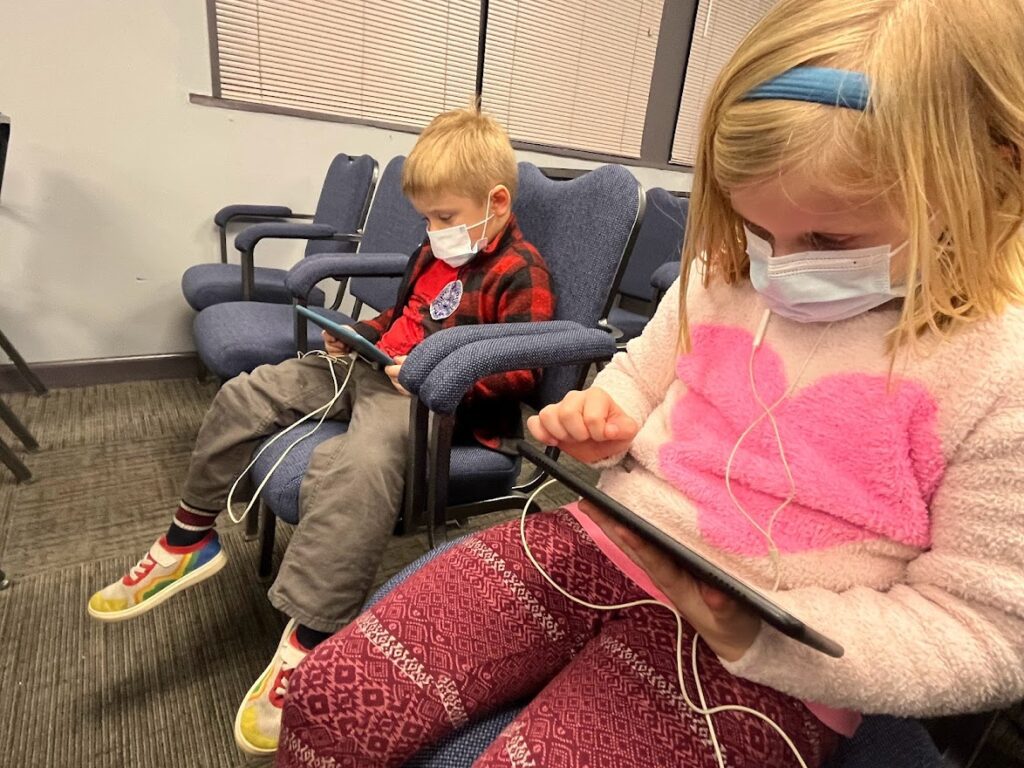
February 14th was Valentine’s Day in Carrboro. The more romantic among us might have had a reservation at Glass Half Full or a quiet dinner at home with our main squeeze. My wife was escorting our oldest kid to his basketball game in Chapel Hill, while I had our two younger kids sitting with me at Carrboro Town Hall for a very exciting work session with the Carrboro Town Council.
The purpose of the work session was to discuss how to proceed with the long-awaited public engagement process for Phases 3 & 4 of the Bolin Creek Greenway. The whole discussion can be viewed on the town’s YouTube channel, but there were a few interesting moments that I want to highlight. Let me start with the briefest backstory I can muster…
Sign up for the Carrboro Linear Parks Project mailing list to get updates on building out Carrboro’s greenway network. Visit the Carrboro Linear Parks Project website for more information. There’s also a helpful FAQ with answers to many questions.
Update: We support the creekside alignment for the reasons detailed here.
The backstory
In the 1960’s the Town of Chapel Hill and the local school district installed a sewer line along the banks of Bolin Creek to serve the newly built Chapel Hill High School. As early as 1994 the residents of Carrboro were envisioning a greenway trail along that sewer easement, and in 2008 the town received matching funds from the federal government to produce a conceptual master plan to determine the feasibility of such a greenway.
The conceptual plan was adopted in 2009 and staff were directed to begin work on Phases 1 & 2. Phases 3 & 4, which comprise the majority of the trail between Homestead Road and Estes Drive, were put on hold pending further public engagement. Town leaders have attempted to restart the conversation around Phases 3 & 4 several times but failed to reach an understanding about how to proceed.
All of that changed on Valentine’s Day 2023. As opposed to more recent attempts in 2016 and 2018 where agreement was out of reach, the February 14th meeting proceeded mostly without acrimony and ended with clear direction given to staff about how to proceed with the final public engagement process. More on that below.
Alternate alignments
The adopted Bolin Creek Conceptual Master plan contains one “preferred alignment”, which is a greenway trail co-located on the creekside sewer easement, and two “alternate alignments”. The alternate alignments were introduced by the consultant as a way to encourage the public and stakeholders to think about three very different approaches to building a greenway along the Bolin Creek corridor.
One alternate alignment was named the “Upland Forest” alternative. This alternative would incorporate some existing forest roads and singletrack to connect Estes Drive with Seawell Elementary School up the hill from Bolin Creek. The Upland Forest alternative was not preferred by many in the community because it would require cutting down a large number of trees in order to place a paved trail where there existed (and still exists today) only narrow gravel forest roads or singletrack. The 2009 plan notes that this alignment would cause conflicts with existing trail users, notably trail runners and mountain bikers who would see the “school side” trails of Carolina North bisected by a paved greenway. Most critically, the largest landholder, UNC, rejected the Upland Forest alternative because they did not want a greater disturbance to the forest. UNC informed town staff that they would only support a greenway trail on top of the existing sewer easement on the UNC property.
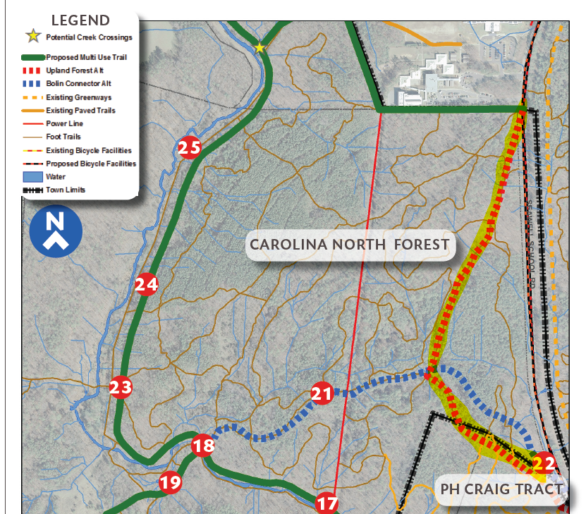
A second alternate route was named the “Bolin Connector” alternative. This trail was very different in that it utilized existing neighborhood roads, like Pathway Drive, to connect trail users to Tripp Farm Road. Tripp Farm Road turns into a gravel service road that cuts west-to-east across the Carolina North property where it terminates at Seawell School Road. The Bolin Connector alternative was rejected by residents at the public meetings back in 2009 because, well, it’s not really a greenway but a neighborhood road. Parents did not want their kids sharing space with cars, and the topography of that route is less favorable than the gentle grades of the creekside easement.
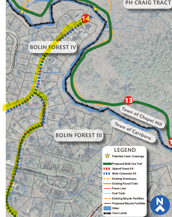
Thus the creekside trail alignment became the “preferred” alignment adopted in the final conceptual master plan. At the time the entire plan was adopted, however, despite being ruled out by the general public and the major landholders, the two alternative alignments were included “for further consideration” alongside the preferred creekside alignment, at the direction of the town council. And that further consideration is now upon us as the town embarks on the final public engagement initiative.
A very critical point about the path ahead for the Bolin Creek Greenway was made by Council Member Sammy Slade. Slade notes that when the town accepted the matching federal funds to hire a consultant to produce the conceptual master plan, and then adopted that plan, the town committed itself to building all four phases outlined in the plan. In other words, the 2009 vote approved an entire greenway, not parts of a greenway. As Council Member Slade remarked during the February 14th meeting: “It is not whether we do Phases 3 & 4; it is which version of Phases 3 & 4 we do.”
Practical alternatives
The preferred alignment’s biggest (and perhaps only) opponent on the Carrboro Town Council is Randee Haven-O’Donnell. At the February 14th meeting Council Member Haven-O’Donnell listed five alternatives that she believes make a more viable greenway network than the preferred alignment adopted in the 2009 plan. Haven-O’Donnell’s five alternatives are: (1) the Cobblestone “neighborhoodway”, (2) the Seawell School Road sidepath, (3) the “Upland Forest” route, (4) the utility path behind Seawell Elementary School, and (5) converting the existing active railroad to UNC’s coal power plant into a trail.
Let’s examine each of these and see how practical they are.
The neighborhoodway
The “neighborhoodway” Council Member Haven-O’Donnell mentions is a series of low-traffic neighborhood streets that connect via sidewalks and eventually link up to the existing Bolin Creek Greenway Phase 1B under Homestead Road.
The first thing you might notice about this alternative is that it is not a greenway but a shared street. One of the primary benefits of the preferred alignment is that it is a dedicated off-road trail that provides a car-free environment for residents to walk and enjoy nature. You cannot get this experience walking alongside Homestead Road.
The second thing to note about this route, strictly from a cycling point of view, is that Cobblestone Drive is pretty steep. The grade and length of the Cobblestone Drive climb is significant enough that it is a cycling segment on the popular Strava fitness app. This means that local cyclists compete with each other for the best time up this road. Routes that are challenging enough for Strava aren’t very appealing for non-competitive cyclists ages 8-80 that the town’s bicycle plan has prioritized.
Seawell School Road Sidepath
Seawell School Road is currently a narrow two-lane road that connects Estes Drive to three schools near Homestead Road. In December, the Town of Carrboro submitted a funding request to NCDOT to construct a separated sidepath along that road which would provide a safe space for bike and pedestrian users.
Leaving aside the difficulty with how a project like this would score for NCDOT funds, the practicality of this project to connect Carrboro neighborhoods to those schools is questionable. Would parents send their kids to ride Hillsborough Road, to Estes Drive, to Seawell School Road? Or would we continue to see everyone driving everywhere? Seawell School Road needs safe facilities for bicyclists and pedestrians, but those improvements would do little to reduce car trips originating from Carrboro neighborhoods.
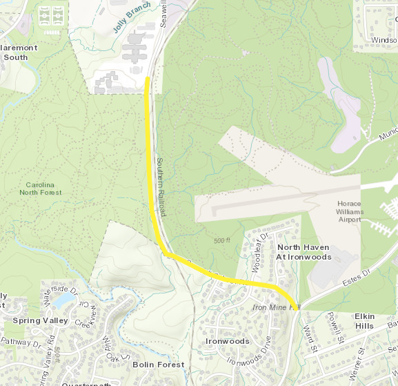
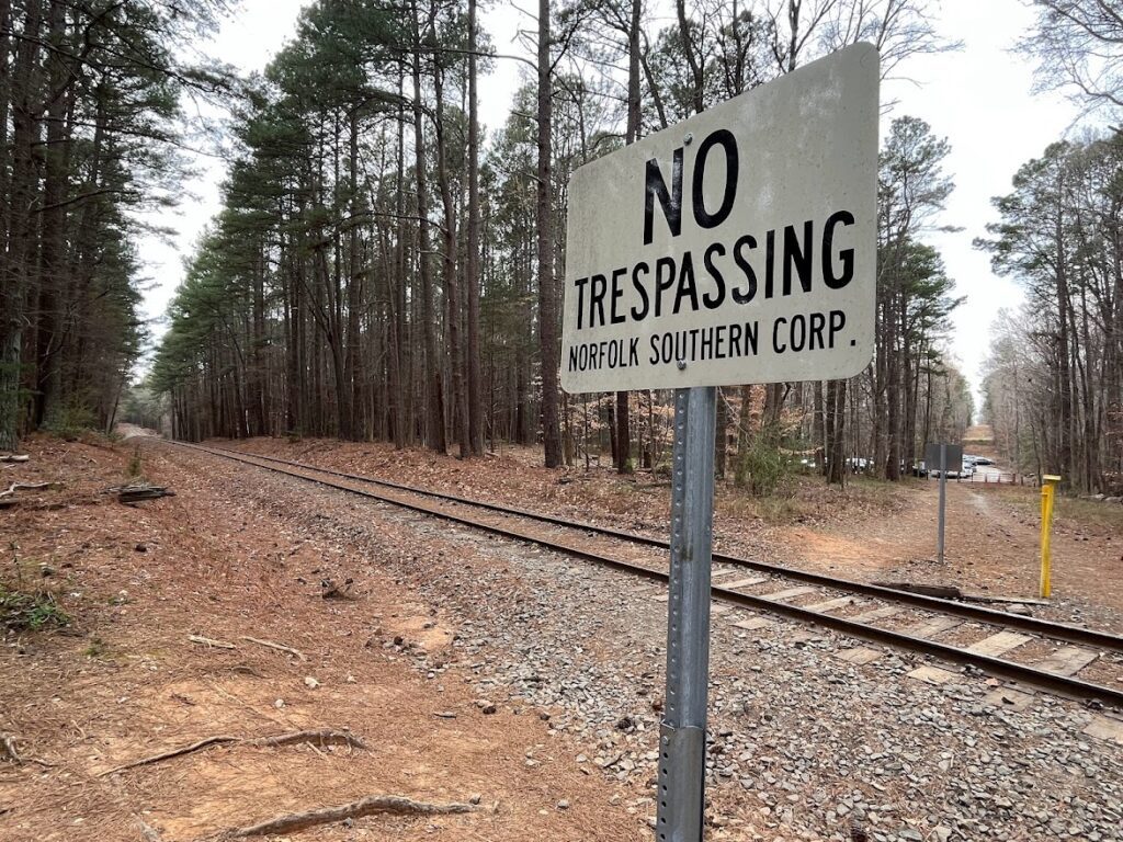
Convert the UNC railroad to a trail
UNC ending coal power production at its plant and the town obtaining the railroad right-of-way all sounds great in theory and I hope it happens in my lifetime. The problem is that there is no guarantee UNC will cease operations at the cogeneration plant in the next decade, and, further, that the railroad owner would sell the track to the town. You may recall that just last year the railroad came through and updated the track, which might give you some idea of what kind of long term planning they have in mind for this line.
Hoping for a UNC rail-to-trail is just that: hoping. Carrboro residents will have to decide for themselves if it’s practical to wait for all the stars to align and the conditions for this alternative to even exist. And just like the Seawell School Road sidepath, a trail along the rail corridor would be great but it doesn’t connect neighborhoods in Carrboro as well as the proposed alignment in the adopted 2009 conceptual master plan.
The Uplands Forest alternative
As mentioned above, the proposed Upland Forest route would turn existing forest roads and singletrack trail into a greenway trail, a process that would include felling a large number of trees.
It’s surprising to me that Council Member Haven-O’Donnell would recommend this as a viable alternative because she has also said many times that her highest priority is climate resiliency and protecting the forest. I couldn’t agree more and this is why advocates for a creekside alignment prefer it: because it would be installed on top of an existing sewer easement and not require a large number of trees to be cut down. In any case, UNC has already declared that they will not allow this type of greenway to be built on their property, so the Upland Forest alternative is dead on arrival.
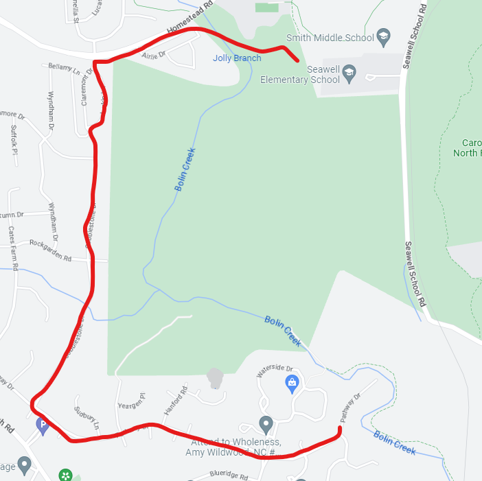
The utility path behind Seawell Elementary
The utility path behind Seawell Elementary can be seen on many maps as the “Duke Energy Corridor”:
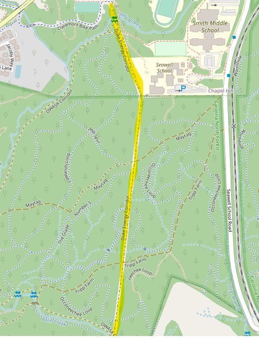
If you’ve hiked around in Carolina North you will know this as the straight gravel access road with the power lines overhead. And you will also know that it has some challenging topography. Again, this trail is so steep and challenging that it actually has two Strava segments.
More importantly, to the south, the Duke Energy Corridor ends in a T-intersection at the OWASA easement and the creek. And then what? A person would still need to travel on the easement to access a neighborhood. If the sewer easement is to remain in its current state, the utility path won’t connect neighborhoods to destinations any better than it does right now. This is not a practical alternative to the preferred alignment in the conceptual master plan.
It’s not just a transportation project
A final point about the idea of “practical alternatives”: greenway trails are not just transportation projects and their practicality extends far beyond getting kids safely to schools. As my friend Alyson West has said, greenways are multisolving projects. They can help take cars off the road, AND they also provide a mechanism to address unmanaged recreational use on a utility easement that is harming the creek. When state water quality officials met with the town back in 2009, they not only said the greenway would be allowed under the Jordan Lake rules, they actively encouraged the town to build it as a way to address the existing conditions caused by the easement’s existence next to the creek.
And in addressing these transportation and environmental needs, the preferred creekside alignment would make this beautiful natural area accessible to everyone in Carrboro. Increasing accessibility to green space and recreation is an important and overlooked outcome for the Bolin Creek Greenway. To see why I say that, I encourage you to read this essay by Mitch Silver, the former head of New York City parks. Ask yourself who feels comfortable walking on an informal trail along a creek behind affluent neighborhoods, and also, who may not feel comfortable being in that space. Having an official town facility along the creek will make Bolin Creek a place where everyone is welcome to enjoy nature right here inside the town limits.
Active transportation, environmental stewardship, and equitable access to recreation in nature: the preferred creekside alignment from the 2009 conceptual master plan addresses all three of these issues simultaneously.
What’s next?
The outcome of the February 14th meeting was direction to town staff to devise a scope of work for the final public engagement and submit that to the town council for approval. Once approved, staff indicated that they would seek to hire some outside help, likely an engineering consulting firm retained by the local metropolitan planning organization. Once a contract is in place, we should expect to see pop-up events in neighborhoods, events at our schools, and perhaps targeted surveys, all of which will be used by the town council to finally make a decision about which alignment the Bolin Creek Greenway will have. Stay tuned!