

TL;DR: A lot of conversation and debate in our community centers on planning, zoning, and development regulations. But…what are these things? Where did they come from? And why are they used? Are they good? Bad? Somewhere in between?
It’s important to understand how land use planning and regulations work, what they can and can’t do, and how they can be used to promote better development outcomes in our communities.
This is the first in a series of posts explaining the basics of planning, zoning, and other land use and development regulations. After exploring some basics, we will exercise your newly acquired planning knowledge by digging into land use issues and opportunities that are more specific to communities in the Triangle.
Background and history of zoning
Development regulations, zoning codes, and development review…what’s the difference?
The simple answer is that development regulations describe a variety of requirements and regulations related to the ways a property is allowed to be used, including what is allowed to (or must be) built on it. This includes things like landscaping requirements, signage, stormwater standards, sidewalks, minimum/ maximum building or lot sizes, height restrictions, and more. Zoning is a specific type of development regulation.
Development review is the formal process and procedures that must be followed when submitting, assessing, or approving/denying applications for development or building permits. (Spoiler Alert: Not all development must be reviewed! More on this later.)
Many jurisdictions combine their development regulations, zoning code, and development review processes into one regulatory ordinance called a Code of Ordinances or sometimes a Unified Development Ordinance (UDO).
For example, Chapel Hill calls their regulatory framework for land use and development the Land Use Management Ordinance which is often shortened to “LUMO.”
Historically, an ordinance would be an actual paper document, but technology has provided the opportunity for most ordinances to also be available online. And this has made land use ordinances (which typically run hundreds to thousands of pages) much more user-friendly!
Why do we need zoning?
Zoning is a way to organize the built environment (i.e., human-made buildings, infrastructure, activities, and boundary lines). Zoning helps make sure that things located close to each other can happily coexist and separates things or uses perceived to be in conflict with each other. Zoning also helps make sure that we don’t put buildings or people in unsuitable or dangerous locations and provides a way to protect places that need protecting. Lastly, it helps us make sure our communities can support a variety of places and ways to live, work, move, and play.
How does zoning work?
Zoning is essentially a set of rules defining what you’re allowed (or not allowed) to do with and on your property. Different sets of rules for the different ways we use land are organized within zoning districts. In communities with adopted zoning codes, every parcel of land is assigned a zoning district, regulating how it can be used and what can be built on it.
Zoning districts have traditionally allowed a single use such as residential (places we live), commercial (places we work), retail (places we shop), industrial (places where things are made), and open space (places like parks and public land). This is based on the concept of keeping the community’s complementary elements (things that are the same) together and keeping apart activities that conflict (or are perceived to conflict). While use-based zoning has historically been used to separate activities perceived to not work well together (like heavy industrial and residential), it can also be used to mix uses that do work well together, like homes and small businesses.
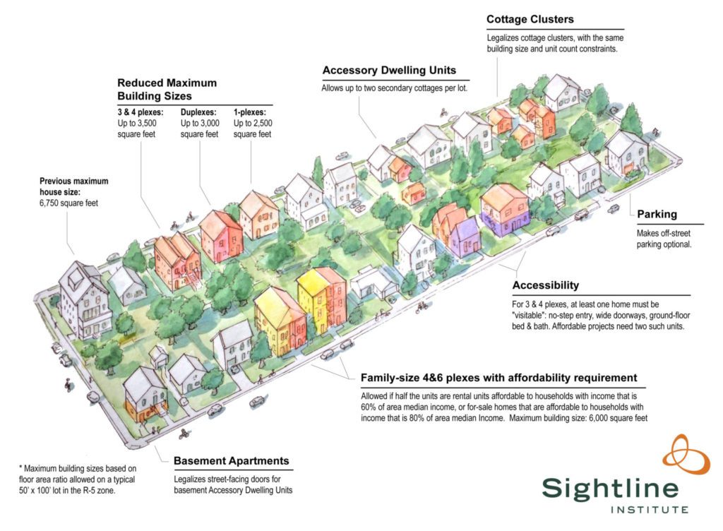
In modern zoning, primary zoning districts (like residential or commercial) are usually subdivided into additional districts, each with more refined rules and requirements. For example, instead of having just one residential zone, communities typically have many residential zoning categories, each with different rules and regulations. Chapel Hill has over 10 different residential zones!
Zoning is also used by municipalities in combination with other development regulations to cultivate development consistency (i.e., sameness). This is achieved by regulating the physical characteristics of the things that we build like size, shape, and (sometimes) design characteristics and defining where on a lot or property those things are allowed to be built. When used in this way, zoning can limit the nearness of things that we perceive to not work well together (i.e., farms and high-rise apartment buildings) and help integrate activities and development that do work well together (like single-family homes, triplexes, and neighborhood retail).
How long has zoning been used?
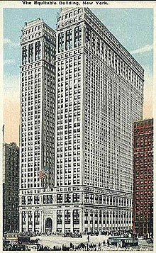
Most planners and historians agree that conventional zoning was born in New York City in 1916 when the Equitable Building was constructed (image). At the time, the 38 story structure was the tallest office building in Manhattan (and the world). It was also so tall that it towered over its neighbors, blocking sunlight from reaching nearby buildings and streets, and casting surrounding areas into darkness even in the middle of the day. Residents of Manhattan were panic-stricken at the thought of living in a city where buildings reached into the sky, but no daylight ever reached the ground.
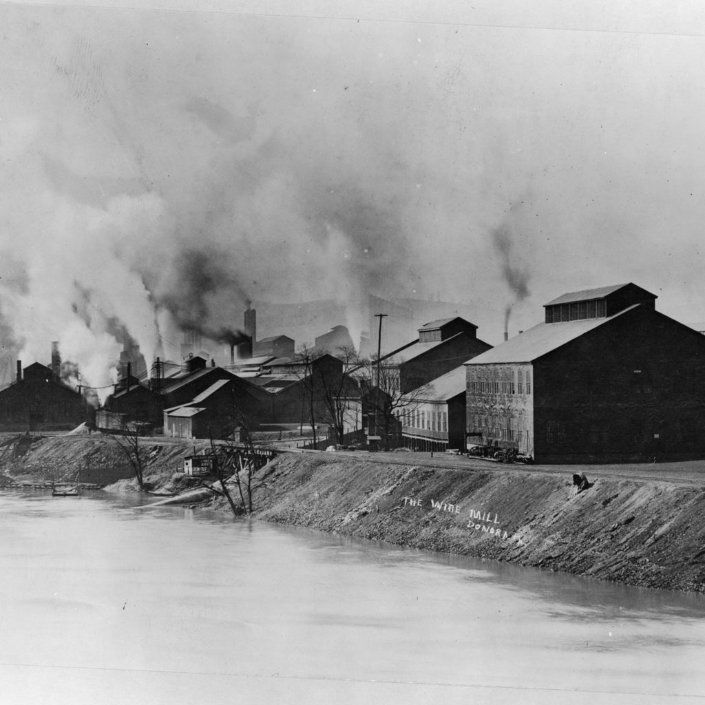
Cities and towns in this era were also still reckoning with the need to coexist with urban industry which, in the early 1900s, looked (and smelled and sounded) much different than in the pre-industrial age. Communities needed a way to manage and plan for compatible and predictable growth and development. The concept of zoning allowed communities to identify categories (zones) where certain activities (uses) were allowed (and, also importantly, not allowed). Assigning each property, lot, and parcel to these different zones provided a simple (albeit, blunt) solution to a complex problem.
Unlike today’s zoning codes which can have hundreds of zoning districts, early zoning (proto-zoning?) usually had just three – residential, commercial and industrial. Early adopters of zoning tended to separate their activity-based zones in ways that made sense in the early 20th century (i.e., pre-automobile). Commercial uses were clustered in the city center with residential uses located close (but not too close) to the business districts. Industrial uses were located further away, where their smells and sounds were less likely to disturb people and businesses.
We will pause here and let you digest everything you’ve learned about zoning. But don’t forget to come back! In the next installment of our zoning series, we will explore the fundamentals and mechanics of zoning!