
TL;DR: A lot of conversation and debate in our community centers on planning, zoning, and development regulations. But…what are these things? And why are they used? Are they good? Bad? Somewhere in between?
It’s important to understand how land use planning and regulations work, what they can and can’t do, and how they can be used to promote better development outcomes in our communities.
This is the third in a series of posts explaining the basics of planning, zoning, and other land use and development regulations. After exploring some basics, we will exercise your newly acquired planning knowledge by digging into land use issues and opportunities that are more specific to communities in the Triangle.
Did you miss the first two posts in this series?
TBB Land Use & Development Primer | 1.1: Background & History of Zoning
TBB Land Use & Development Primer | 1.2: Legal Foundations of Zoning
Anatomy of a Zoning Ordinance (Part 1)
I looked up my zoning once. It was an incomprehensible mess of legalese. Am I supposed to know what this means?
We totally hear you. Unfortunately, zoning codes and development regulations are usually written to protect a municipality from legal action and not to be user-friendly or fun to read. The good news is that, once you understand a few vital components, you’ll be able to easily find your way around most zoning ordinances. The other bit of good news on the horizon is that many communities are adopting updated ordinances that are significantly easier to read and use. A notable example is the recently adopted Kannapolis Development Ordinance which uses graphics and an approachable layout to communicate important regulations.
So you can make zoning less confusing?
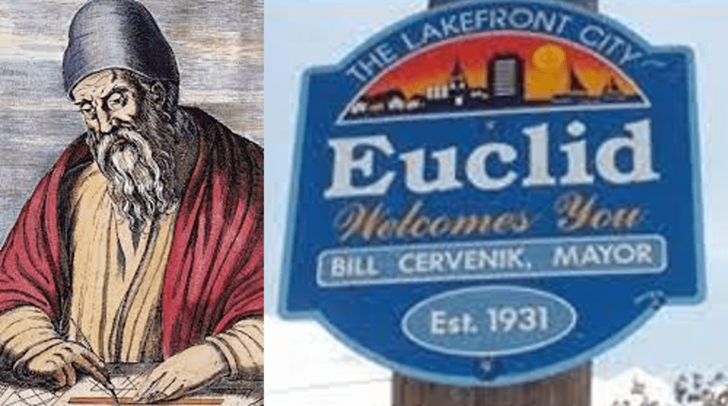
Obviously! Let’s begin our journey through the anatomy of a zoning ordinance by reviewing the “building blocks” of zoning codes. Most communities use conventional (or Euclidean) zoning, so we will start there.
Wait, I thought you said this would be less confusing. But now this sounds like math. What’s Euclidean zoning?
No – not math, I promise. We’ve mentioned Euclidean zoning a few times. It’s just another name for the conventional type of zoning that most communities use, remember? It’s named after Euclid, Ohio and the US Supreme Court case that upheld a local government’s right to enact zoning.
Okay, carry on.
Conventional (or Euclidean) zoning is based on the uses or the activities allowed on a property (check out TBB Land Use & Development Primer | 1.1: Background & History of Zoning if you need a refresher on land uses). There are two critical components to know about – the text-based zoning ordinance describing allowed uses and dimensional standards for each of the community’s zoning districts and the zoning map identifying the zoning designation for every parcel of land in the town or city. To be valid, both the zoning ordinance and zoning map must be adopted by the community’s governing body. In North Carolina, communities must also have an adopted comprehensive plan to enact zoning (Chapter 160D).
Wait. What if the community does all that work to write the ordinance and then something needs to be changed?
No worries! If needed, the zoning ordinance can be changed in a few ways. This is good, because communities need flexibility to respond to changing conditions, needs, and values. An existing ordinance can be amended to revise, delete, or add specific provisions. There are several ways this can be done and we will explore this topic more in another post. The other option is starting from scratch, drafting and adopting an entirely new zoning or land use management ordinance (you may remember from our first post in the series that some communities opt to combine their zoning and development regulations in a land use management ordinance or unified development ordinance).
Well, that’s good. I was worried we’ve been using the same zoning ordinance for like a hundred years!
Yeah, we know it can feel that way sometimes. Most communities do their best to adapt their zoning ordinance and development regulations. But it’s always a balancing act between varying interests and values of the community.
Cool, cool. So, anyway, when I tried to look up my zoning, there were like a thousand different categories. And some properties had more than one zoning designation. What is even happening?
Good observation. Conventional zoning ordinances usually include a few different “flavors” of zoning. Here’s a metaphor. Chocolate, vanilla, and strawberry taste different and look different, but they are all ice cream. Likewise, in North Carolina, zoning “flavors” typically include base districts, overlay districts, and conditional districts. They have different functions and are used to satisfy different development appetites, but they are all still zoning. There are others, but for now this is enough. One important point to keep in mind going forward: zoning districts are not the same across communities. For example, development requirements for Chapel Hill’s residential zoning district can be very different from a residential zoning district in Cary. Sticking with our ice cream metaphor, strawberry ice cream from Mapleview Farm might look and taste much different than strawberry ice cream from Cold Stone Creamery.
Well, now I want ice cream. Do we have to keep talking about zoning?
You know what they say. Ice cream always tastes better after talking about zoning.
…
…
Nobody says that.
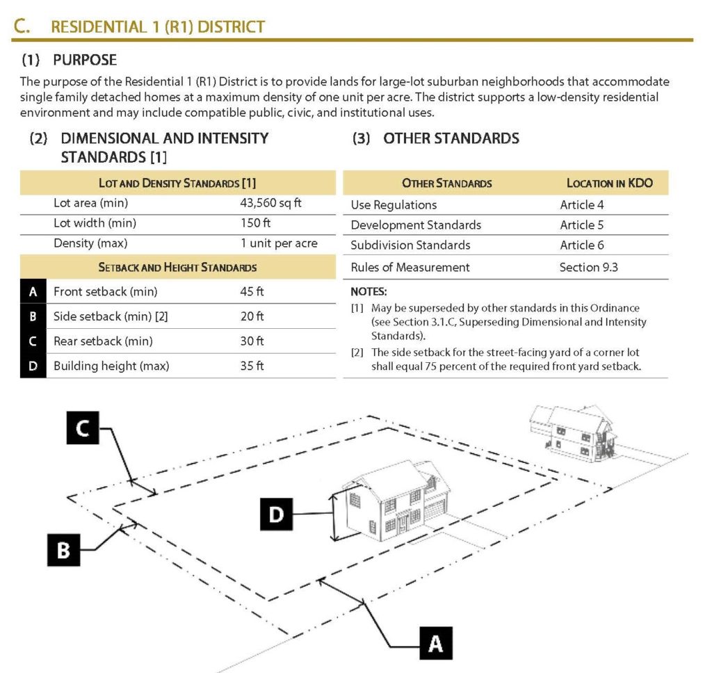
Whatever. Back to zoning. Let’s dig a little deeper into our flavors. We can start with base zoning districts. These are the workhorses of the zoning world. An example of base district in Chapel Hill’s code is Residential 1 (R-1). A community can have many base districts or just a few. We will use the R-1 district to help explain some of the other concepts, so keep it in mind. The zoning ordinance describes the following for each base district:
- Purpose (essentially the reason it is needed and the type of development it’s intended to generate)
- Allowed uses (activities)
- Dimensional standards (minimum size of each lot, building setbacks, maximum height, and so forth)
- Special regulations, requirements, or prohibitions.
We will explore these in more detail so, don’t worry if you’re still not sure what they mean. It’s important to know that any property sharing a base zoning district designation is subject to the same permitted uses and dimensional standards “no matter where it is within the city or county” and that no “site-specific, individualized conditions are allowed.” This just means that a property zoned R-1 in Southern Village has the same requirements as a property zoned R-1 on MLK, Jr. Blvd. This consistency differentiates base districts from conditional or special districts (described later).
Wait…there’s more?
Yes! Let’s move on to overlay districts. Overlay zoning districts are used in special areas (like an airport or historic district) to add additional or special requirements on top of the base district requirements. This means a property can be assigned more than one zoning district. So, if our base district is a scoop of vanilla ice cream, an overlay is like having sprinkles on top. Likewise, a property can be assigned both a base district (ex. R-1) and an overlay district (ex. an airport hazard overlay). This property would be subject to all of the requirements and allowed uses in the residential district plus the added requirements of the airport hazard overlay (ex. building height limit).
That HAS to be it, right? Right?!
Stay with me. I have one more for today and then we’ll take a break. The last flavor of zoning we’ll walk through is conditional zoning. This one is a little tricky to pin down, so I’ll give you some information and then we’ll walk through an example (not ice cream, I promise). Conditional zoning districts are kind of like a “two-for-one.” In communities that use them, some or all of the base zoning districts have a twin or parallel conditional district. For example, Chapel Hill has both a Residential 1 (R-1) base district and a Residential-1 conditional district (R-1 CZD)
But…why?
Yeah. It’s weird. There are a few key points:
-
- The only way a conditional zoning district can be applied is if the property owner requests it through a rezoning (a formal process changing a property’s existing zoning designation).
- The property owner’s rezoning request triggers a legislative review and approval process. During this process, the local government and the property owner negotiate a set of additional requirements on top of the requirements of the applicable base and (if relevant) overlay zoning districts.
- The negotiated additional requirements (i.e., the conditions) must be approved by both the applicant and local government.
- Any negotiated conditions must directly address or mitigate potential impacts “generated by the development or use of the site” (North Carolina General Statute 160D-703(b)).
- The local government cannot demand conditions that aren’t otherwise allowed under state law (ex. design requirements for single family homes) unless the applicant explicitly consents to the condition in writing.
So, in a nutshell, the use of conditional zones and the process of negotiating the conditions gives the local government some bargaining power during the rezoning process. Sometimes this is a good thing, like asking a developer to provide more public open space or enhanced streetscaping. But it also has a nasty habit of slowing the rezoning and development approval process to a pace that makes a tortoise look reckless. More on that another time.
I think I understand? Maybe? It would be REALLY helpful to walk through an example.
Lucky for you, we have one ready! Conditional zoning can be confusing, so here’s a “real world” example.
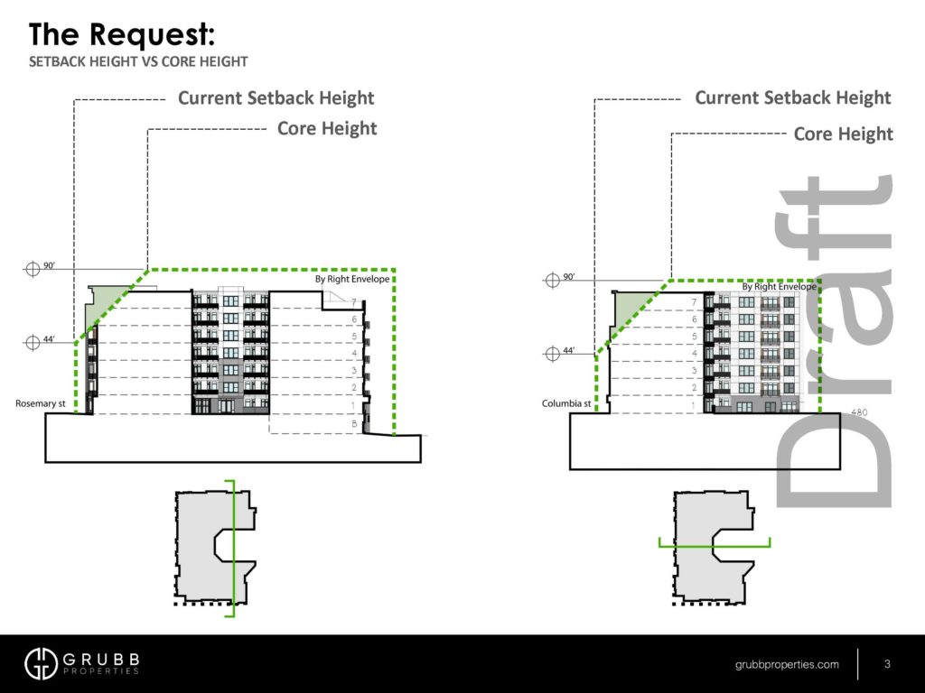
A conditional rezoning application was submitted to the Town of Chapel Hill on behalf of Grubb Properties, LLC on July 21, 2021. The applicant requested a rezoning of a property located at 101 E. Rosemary Street to allow the construction of a 7-story multifamily building.
The property is currently zoned Town Center 2 (TC-2). This zone allows multifamily development but building heights are limited to 4 stories. The developer’s application is requesting:
- Rezoning the property to Town Center 3 Conditional Zoning District (TC-3 CZD) allowing 7-stories to be built instead of 4;
- A modification to TC-3 CZD’s allowable setback height limit (from 44’ to 90’ on all four sides).
The rezoning plus the dimensional modification to the setback height limit would allow the builder to construct nearly twice as many residential units (75 versus 140) as could be built by-right in TC-2.
The Town of Chapel Hill is still (as of July 2022) negotiating the site-specific conditions that will need to be met in exchange for the rezoning approval. Some that have been discussed include resident age (at least 22); tenure restrictions (all leaseholders must live in the unit); streetscape improvements on East Rosemary Street (brick pavers and street trees); a 10-year parking strategy plan for up to 130 resident vehicles; road improvements accommodating ingress and egress and service vehicle loading zones; and an affordable housing plan and performance agreement. Town Council is on summer break so we will have to wait until they reconvene to see how this process plays out.
In our next installment we will continue our journey through the zoning ordinance. Sneak peek: We’ll be digging into the table of uses and dimensional standards for each of the community’s zoning districts.