
Last Wednesday’s Chapel Hill Town Council meeting featured a real humdinger of a presentation from Rod Stevens and Jen Keesmaat.
First, some background: Stevens and Keesmaat are both planners; Stevens, of Bainbridge Island, Washington, wrote the 2021 Housing Report that said we need more housing, and Keesmaat, formerly Toronto’s chief planner, is currently leading our Complete Communities planning effort. (Stevens is also part of that team.)
They returned to Chapel Hill to give an update on their progress.
First, what did they tell the Council?
They presented some circles on a map of town roughly corresponding to areas of town that are not already “built out” with single family housing.
(Note: This was a day before these possible changes to the LUMO dropped).
The consultants told council that the most important path to pursue to build the town’s housing needs was to look at the UNC Finley Golf Course (200 acres) and parts of Carolina North. (Ed note: Parts of Carolina North were permanently preserved by UNC in 2009. Stevens is talking about the spot currently occupied by the airport runway, where UNC’s plans to build a campus extension in 2009 fizzled when the economy tanked.)
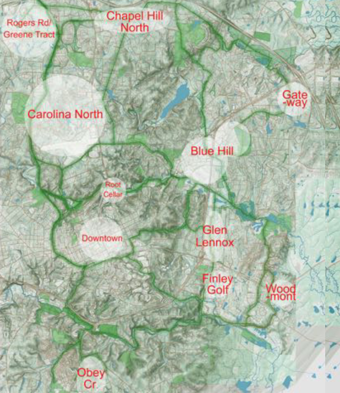
They presented an overall vision of a “complete community”
This differs from the complete communiTIES they discussed earlier. We saw a bunch of master-planned developments in these circles connected by a comprehensive system of fantasy greenways that could plausibly (?) be funded by a $100 million bond issue.
They told Town Council to act like a board of directors of an organization
And they told them to strategically master plan the entire town, creating dutiful mixes of well-designed, attractive, right-sized housing developments.
What was our impression of the consultants and this presentation?
Um…
While Stevens has done an impressive job in laying the groundwork in Chapel Hill for a conversation about housing, it seems that he has not fully engaged existing data, including GIS maps of the town and existing studies and reports.
Stevens did not perform a detailed analysis of the town’s future growth prospects. Indeed, elements of his analysis were not standard capacity analysis at all, such as calculating the density of existing developments (see slide 18) in town based on gross density (units/ parcel area) instead of net density (units/ buildable area net conservation areas and unbuildable land). This underestimates practical densities, and could lead to unfavorable ratings of projects like South Creek (5 units/acre gross, 16 units/acre net) simply due to the configuration of buildable land on a parcel. For a much better analysis, look no further than this report, which was produced over the summer by the consultant working on the Transit Oriented Development Planning project.
In addition, it appeared that neither consultant asked the town’s planning department for their assistance. At times during Wednesday’s Council meeting, Stevens seemed to openly disparage the planning department, giving the impression that town staff were unaware of the challenges facing the town. (Ed note: Having worked with town staff and watched their output, we’re confident that they are quite competent and they understand the challenges facing the town. They often get the brunt of complaints and face the wrath of citizen-led groups challenging their work, which must suck! We’re here to say: We appreciate what you’re doing, and understand how difficult it must be given :waves-hands:)
They weren’t aware of our GIS maps?
Back to the meeting: A key moment was when Council member Tai Huynh asked if it would be possible to visualize the consultant’s proposed greenway network on the existing greenway network. He was told that that would be impossible due to poor readability of the existing greenway map.
The existing greenway map is interactive and zoomable, and we’re sure that the underlying data would have probably been made available had they asked town planning staff. Also, open-source resources exist for this stuff. We were able to put something together while Stevens was still talking…
Last night Council Member @TaiBuilds asked for an overlay of the envisioned greenways on the current greenway map. The consultant said that would be tough. Our services are available…. pic.twitter.com/qHIGJh7PWV
— triangleblogblog (@triblogblog) September 29, 2022
Another example occurred when the consultant claimed the town does not have good topographic maps, when these are also available through various town data resources.
Also, the consultants did not seem to think about feasibility at all
The vision the consultants presented to a large degree depends on cooperation from UNC in either building housing or dedicating land for housing. We think it’s worth pressuring UNC to contribute more to the town’s housing and transportation infrastructure, but we also know this: the university is beholden to our state’s Republican-led legislative body, which has championed moving UNC’s system office to Raleigh and doesn’t seem super keen on helping it’s flagship R1 university flourish.
Not recognizing these political and structural difficulties is irresponsible. Yes, if we could wave our hands and acquire a billion dollars…

we could transform the land and do all of these amazing things. But we live in reality, and presenting a strategy that relies solely on UNC is not going to go anywhere. We’re also really disappointed that their strategy failed to mention one of the most transformative projects already in the pipeline (NSBRT).
The consultants also suggested floating a $100 million bond issue to finance a greenway network. It’s worth noting that Chapel Hill Transit is struggling to get the final $17 million together to kick off the NSBRT project which includes a lovely mixed use path down MLK, one of the town’s main corridors.
Similarly, when asked questions about housing affordability, equity, and restorative justice, the consultants gave examples of tenants rights measures that (unfortunately) may not be legal in North Carolina, policies that are already enacted in Chapel Hill (like inclusionary zoning), and an anecdote about a development elsewhere in the country where the market price of unsubsidized units ended up being as low as the subsidized units.
An exercise in giving town council policy recommendations should include some kind of analysis of what is legally possible and/or not already being done and perhaps some resources to assist in implementation.
One year out from our initial planning exercise with Stevens, we’re not sure what direct actionable advice is being provided to the town — or what the next steps will bring. Master planning an entire town or part of a town often involves planning consultants. Is this that? Or will we plan a new plan after this plan is done?
We give Stevens a lot of credit for, as Michael Parker noted on Wednesday, getting the council to the point where they are discussing the urgent need to add more housing. We’re looking forward to two concrete processes that could get us moving towards a complete community—the North/South BRT project and the revision of the town’s LUMO.